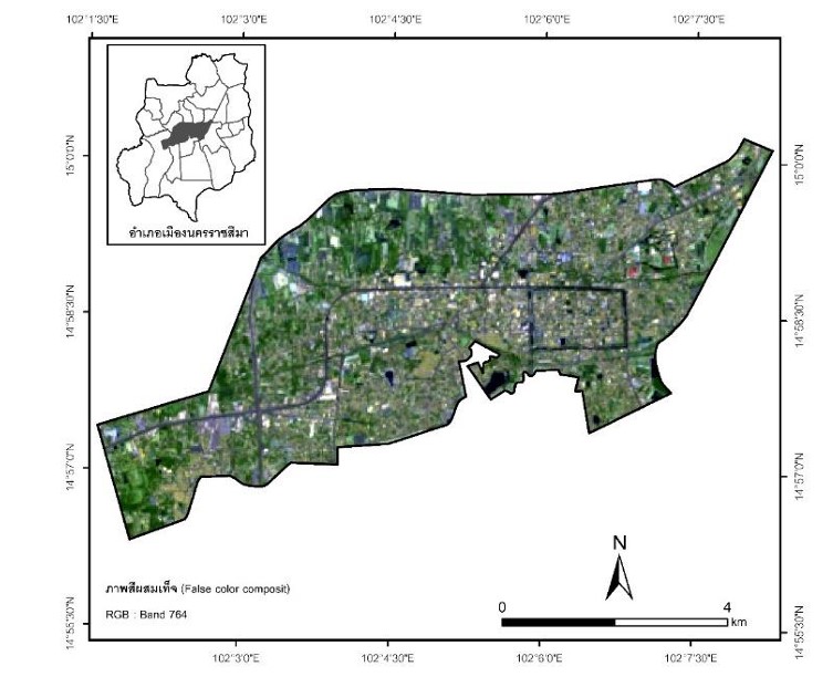
การหาความสัมพันธ์ระหว่างอุณหภูมิพื้นผิวกับดัชนี NDVI NDWI และ NDBI ในเขตเทศบาลนครนครราชสีมา
Keywords:
อุณหภูมิพื้นผิว, ดัชนีผลต่างพืชพรรณ , ดัชนีความต่างความชื้นของน้ำ , ดัชนีผลต่างและความปกติสิ่งก่อสร้างAbstract
The purpose of this research was to study land surface temperature and the relationship between NDVI, NDWI, and NDBI in 2009 and 2021 in 2 time periods from Landsat 5 and 8 satellite images using Google Earth Engine open source software to analyze the data. It was found that the land use change between 2009 to 2021 has changed land use from agriculture to Urban and built-up area and the land surface temperature study is summer season found that, the maximum surface temperature increased from 29.71 °C in 2009 to 34.78 °C in 2021, and in winter, the maximum surface temperature increased from 30.12 °C in 2009. to 31.82 °C in 2021. Furthermore, studies show the relationship between LST and NDVI, NDWI were negatively correlated. And inversely variable The surface temperature and the NDBI index were inversely positively correlated. The results of this study can be used to plan appropriate land use and cope with climate change.
Downloads
References
กมลวรรณ ปรีเปรมโมทย์. (2561). การหาดัชนีความสัมพันธ์ของการเปลี่ยนแปลงการใช้ที่ดินกับปรากฏการณ์เกาะความร้อนของเมืองไมซ์พัทยา. (วิทยานิพนธ์ปริญญาวิทยาศาสตรมหาบัณฑิต) มหาวิทยาลัยศรีนครินทรวิโรฒ.
กรมอุตุนิยมวิทยา. (2563). สถิติอุณหภูมิอากาศ อุณหภูมิสูงสุด. สืบค้นเมื่อวันที่ 20 ธันวาคม 2566 เข้าถึงได้จาก http://www.tmd.go.th/programs /uploads/tempstat/max_stat_latest.pdf.
ญาโณทัย แก้วทอง. (2564). การศึกษาและวิเคราะห์ความสัมพันธ์ของอุณหภูมิพื้นผิวต่อพื้นที่สีเขียวด้วยเทคนิคการรับรู้ ระยะไกล กรณีศึกษา : อำเภอเมืองพิษณุโลก จังหวัดพิษณุโลก. (ปริญญาวิทยาศาสตรบัณฑิต) มหาวิทยาลัยนเรศวร.
นราธิป เพ่งพิศ สุพรรณ กาญจนสุธรรม แก้ว นวลฉวี และ ภัทราพร สร้อยทอง. (2560). การศึกษาความสัมพันธ์ระหว่างอุณหภูมิพื้นผิวดินกับพื้นที่ชุมชน และสิ่งปลูกสร้าง กรณีศึกษา อำเภอเมืองจังหวัดระยอง. วารสารเทคโนโลยีภูมิสารสนเทศ มหาวิทยาลัยบูรพา. 2(3) , 27-40.
ปริยานุช โสภา. (2562 ). การหาความสัมพันธ์อุณหภูมิพื้นผิวจากข้อมูลจากดาวเทียม LANDSAT 8 ระบบ TIRS กับ ค่าดัชนีพืชพรรณค่าเน้นภาพพืชพรรณและดัชนีสิ่งปลูกสร้างในพื้นที่เขตกรุงเทพและปริมณฑล. (วิทยานิพนธ์ปริญญาวิศวกรรมศาสตรมหาบัณฑิต) จุฬาลงกรณ์มหาวิทยาลัย.
สำนักงานกองทุนสนับสนุนงานวิจัย. 2559. รายงานการสังเคราะห์และประมวลผลสถานภาพองค์ความรู้ด้านเปลี่ยนแปลงสภาพภูมิอากาศ ครั้งที่ 2 พ.ศ. 2559. สำนักงานกองทุนสนับสนุนงานวิจัย: กรุงเทพมหานคร.
เสาวนีย์ วิจิตรโกสุม. (2552). การจัดการทรัพยากรน้ำในลุ่มน้ำลำตะคองแบบบูรณาการ. (วิทยานิพนธ์ปริญญาวิทยาศาสตรดุษฎีบัณฑิต) จุฬาลงกรณ์มหาวิทยาลัย.
Dousset, B., & Gourmelon, F. (2003). Satellite multi-sensor data analysis of urban surface temperatures and land cover. ISPRS Journal of Photogrammetry and Remote Sensing. 58, 43-54.
Faizan, O. M. (2021). Monitoring land use/land cover change and its impact on variations of land surface temperature rapidly urbanizing island using google earth engine (GEE)-a case study of Delhi, India. Plan Insights Res Paper, 1–25.
USGS. (2013). Using the USGS Landsat 8 Product. Accessed March 24, 2024, Retrieved from http://landsat.usgs.gov/Landsat8_Using_Product.php.

Downloads
Published
How to Cite
Issue
Section
License
Copyright (c) 2024 Nakhon Ratchasima Rajabhat University

This work is licensed under a Creative Commons Attribution-NonCommercial-NoDerivatives 4.0 International License.


