
Development of a Spatial Model for Estimating Aboveground Carbon in Mixed Deciduous and Dry Dipterocarp Forest Using Remote Sensing Data: A Case Study of Wang Samran Community Forest, Lampang Province
Keywords:
aboveground carbon, Sentinel-2, vegetation indices, community forest, mixed deciduous and dry dipterocarp forestAbstract
Background and Objectives: Forest ecosystems play an important role in Carbon stock and climate change mitigation because forests can accumulate aboveground biomass and store large amounts of carbon in living vegetation. Therefore, accurate estimation of aboveground biomass and carbon storage is essential for forest resource monitoring, sustainable forest management, and the development of community-level carbon credit mechanisms. However, assessment based solely on field data is time-consuming and labor-intensive. Consequently, Sentinel-2 satellite imagery, which provides multiple spectral bands and suitable spatial resolution for vegetation analysis, has been applied in this study. The objective of this research was to estimate aboveground biomass and aboveground carbon storage in the Mixed Deciduous and Dry Dipterocarp Forest of Ban Wang Samran Community Forest, Lampang Province, by integrating field data with Sentinel-2 imagery in order to analyze the relationships among spectral variables, develop an aboveground biomass estimation model, and compare satellite-derived results with field-based data.
Methodology: This study was conducted in Ban Wang Samran Community Forest, Lampang Province. Field data were collected from 17 sample plots and used to calculate aboveground biomass by applying allometric equations, while aboveground carbon was estimated using a constant factor of 0.47. These field-derived values were used as reference data for model development and validation. At the same time, Sentinel-2 satellite imagery covering the study area was processed to extract reflectance values from vegetation-related bands, including the blue, green, red, and near-infrared bands. In addition, 12 vegetation indices were calculated, namely EVI2, GNDVI, MSAVI, NDMI, NDRE, NDVI, SAVI, SR-RE, SR, VARI, MTVI2, and RTVIcore. Relationships between field-based carbon values and satellite-derived variables were then analyzed using linear regression, and the most suitable variables were selected based on the coefficient of determination (R²) for the development of a multiple linear regression model to estimate aboveground biomass. Furthermore, values derived from field measurements and satellite data were compared using inferential statistics, a paired t-test at the 95% confidence level, and Pearson’s correlation coefficient.
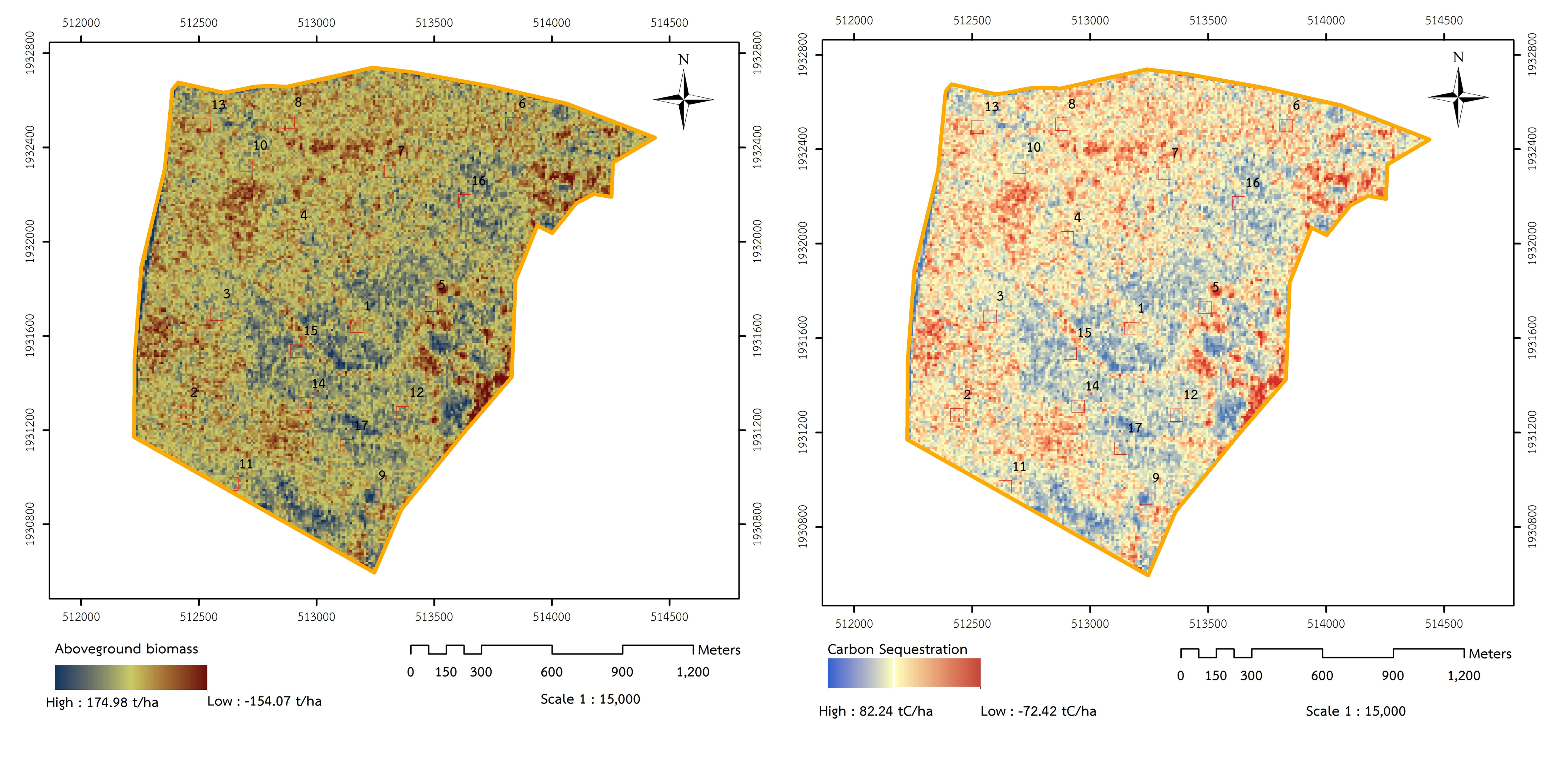
Main Results: Field survey results revealed that the Mixed Deciduous and Dry Dipterocarp Forest in the study area had a moderate potential for biomass accumulation and carbon storage. The mean aboveground biomass was 71.62 t/ha, with a minimum of 52.43 t/ha and a maximum of 140.52 t/ha. Mean aboveground carbon storage was 33.66 tC/ha, ranging from 24.64 to 66.04 tC/ha. Analysis of the relationship between aboveground carbon storage and Sentinel-2 variables showed that VARI was the best single predictor, with the regression equation y = 0.0009x + 0.0109 and an R² value of 0.28. The next best predictors were NDMI, MTVI2, and the red band, each with an R² of 0.12. Some variables, such as SR-RE, NDRE, and RTVIcore, could not explain the variation in the data. To improve estimation performance, a multiple linear regression model was developed using VARI and SR, yielding the equation: AGB = 409.313 + 996.771(VARI) - 165.375(SR), with an R² of 0.64. Comparison between field-based values and Sentinel-2-derived estimates showed that the two approaches produced very similar mean values. The paired t-test indicated no statistically significant difference at the 95% confidence level, and Pearson’s correlation coefficient was r = 0.80, indicating a strong positive relationship between the two datasets.
Conclusions: The findings of this study highlight the effectiveness of integrating Sentinel-2 satellite imagery with field-based inventory data for estimating aboveground carbon storage in the Mixed Deciduous and Dry Dipterocarp Forest of Ban Wang Samran Community Forest, Lampang Province. Although individual spectral variables had limitations in explaining data variation, combining VARI and SR significantly improved model performance. The statistical results, which showed no significant difference between field-based and Sentinel-2-derived values, together with the high correlation coefficient, support the potential of Sentinel-2 data for carbon estimation at the sample plot level. Therefore, the developed model can serve as a practical tool for sustainable monitoring and assessment of community forest resources and for supporting the development of local carbon credit initiatives.
References
Chave, J., Andalo, C., Brown, S., Cairns M.A., Chambers, J.Q., Eamus, D., Fölster, H., Fromard, F., Higuchi, N., Kira, T., Lescure, J.P., Nelson, B.W., Ogawa, H., Puig, H., Riéra, B., & Yamakura, T. (2005). Tree allometry and improved estimation of carbon stocks and balance in tropical forests. Oecologia, 145(1), 87-99.
Ghosh, S.M., & Behera, M.D. (2018). Aboveground biomass estimation using multi-sensor data synergy and machine learning algorithms in a dense tropical forest. Applied Geography, 96, 29-40.
Immitzer, M., Vuolo, F., & Atzberger, C. (2016). First Experience with Sentinel-2 Data for Crop and Tree Species Classifications in Central Europe. Remote Sensing, 8, 166.
Imran, A.B., Khan, K., Ali, N., Ahmad N., Li, A.A., & Shah, K. (2020). Narrow band based and broadband derived vegetation indices using Sentinel-2 Imagery to estimate vegetation biomass. Global Journal of Environmental Science and Management, 6(1), 97-108.
Jaroonudomsombut, J. (2018). Application of vegetation indices for aboveground biomass estimation in different forest types using landsat 8 imageries data: A case study of Khao Yai National Park. Department of Forest Management, Faculty of Forestry, Kasetsart University, Bangkok. (in Thai)
Khunrattanasiri, W., Amarakul, A., Rianthakool, L., & Hutayanon, T. (2024). Comparative study of Landsat 9 and Sentinel-2 satellite data for above-ground carbon sequestration estimation at Mae Moh mine reforestation site, Lampang province, Thailand. Agriculture and Natural Resources, 58(2), 175-182.
Legesse, F., Degefa, S., & Soromessa, T. (2024). Estimating carbon stock using vegetation indices and empirical data in the upper awash river basin. Discover Environment, 2, 137.
Li, C., Zhou, L., & Xu, W. (2021). Estimating Aboveground Biomass Using Sentinel-2 MSI Data and Ensemble Algorithms for Grassland in the Shengjin Lake Wetland, China. Remote Sensing, 13, 1595.
Lu, D. (2006). The potential and challenge of remote sensing-based biomass estimation. International Journal of Remote Sensing, 27(7), 1297-1328.
Nitu, A., Florea, C., Ivanovici, M., & Racoviteanu, A. (2025). NDVI and Beyond: Vegetation Indices as Features for Crop Recognition and Segmentation in Hyperspectral Data+. Sensors, 25, 3817.
Office of Natural Resources and Environmental Policy and Planning. (2022). Thailand long-term low greenhouse gas emission development strategy (revised version). Office of Natural Resources and Environmental Policy and Planning, Ministry of Natural Resources and Environment. (in Thai)
Ogawa, H., Yoda, K., Ogino, K., & Kira, T. (1965). Comparative ecological studies on three main types of forest vegetation in Thailand II. Plant biomass. Natural and Life in Southeast Asia, 4, 49-80.
RECOFTC. (2026). Introduction to community forests: What is a community forest?. https://thaicfnet.org/intro. (in Thai)
Ruangsanka, S. (2023). Ecosystem Services of Community Forest and Quality of Life and Environment. Journal of Interdisciplinary Innovation Review, 6(5), 307-320. (in Thai)
Royal Forest Department. (2017). Project of Ban Sam Ran Community Forest. Forest Resource Management Office No.3 (Lampang). Royal Forest Department. (in Thai)
Royal Forest Department. (2022). A database developed from the aboveground biomass model for community forests. Community Forest Management Office, Royal Forest Department. (in Thai)
Saatchi, S.S., Harris, L.N., Brown, S., Lefsky, M., Mitchard, E.T.A., Salas, W., Zutta, B.R., Buermannb, W., Lewis, S.L., Hagen, S., Petrova, S., Whiteh, L., Silman, M., & Morel, A. (2011). Benchmark map of forest carbon stocks in tropical regions across three continents. In Proceedings of the National Academy of Sciences of the United States of America, 108, 9899-9904.
Saini, R. (2023). Integrating Vegetation Indices and Spectral Features for Vegetation Mapping from Multispectral Satellite Imagery Using AdaBoost and Random Forest Machine Learning Classifiers. Geomatics and Environmental Engineering, 17(1), 57-74.
Sengbuntan, B., Diloksumpun, P., & Diloksumpun, S. (2023). Species Diversity and Carbon Storage in Biomass of Tree and Sapling in the Ban Nong Kwang Community Forest, Uttaradit Province. Thai Journal of Forestry, 42(2), 155-168. (in Thai)
Sharifi, A., & Felegari, S. (2023). Remotely sensed normalized difference red-edge index for rangeland biomass estimation. Aircraft Engineering and Aerospace Technology: An International Journal, 95(7), 1128-1136.
Slik, J.W.F., G. Paoli, K. McGuire, N. Zweifel. (2013). Large trees drive forest aboveground biomass variation in moist lowland forests across the tropics. Global Ecology and Biogeography, 22,1261-1271.
Thailand Greenhouse Gas Management Organization. (2015). Establishment of sampling plots and data collection procedures for forest-based projects. Thailand Greenhouse Gas Management Organization, Bangkok, Thailand. (in Thai)
Thailand Greenhouse Gas Management Organization. (2016). Thailand Voluntary Emission Reduction Program Reference Manual: Forestry and Agriculture Sector. Thailand Greenhouse Gas Management Organization, Bangkok, Thailand. (in Thai)
Vickers B., Trines, E., & Pohnan, E. (2012). Community guidelines for accessing forestry voluntary carbon markets. Food and Agriculture Organization of the United Nations, Regional Office for Asia and the Pacific Bangkok, Thailand.
Wu, J., Lin, L., Zhang, C., Li, T., Cheng, X., & Nan, F. (2023). Generating Sentinel-2 all-band 10-m data by sharpening 20/60-m bands: A hierarchical fusion network. ISPRS Journal of Photogrammetry and Remote Sensing, 169, 16-31.
Xing, N., Huang, W., Xie, Q., Shi, Y., Ye, H., Dong, Y., Wu, M., Sun, G., & Jiao, Q. (2020). A Transformed Triangular Vegetation Index for Estimating Winter Wheat Leaf Area Index. Remote Sensing, 12, 16.
Xu, W., Cheng, Y., Luo, M., Mai, X., Wang, W., Zhang, W., & Wang, Y. (2025). Progress and Limitations in Forest Carbon Stock Estimation Using Remote Sensing Technologies: A Comprehensive Review. Forests, 16(449), 1-36.
Zhou, Q., Neigh, C.S.R., Ju, J., Wooten, M., Zhu, Z., Tomoaki, M., Campbell, P.K.E., Sridhar, M.K., Baker, B.W., & Leite, R.V. (2026). Global uncertainty assessment of vegetation indices from NASA’s Harmonized Landsat & Sentinel-2 Project. Remote Sensing of Environment, 332, 115084.
Downloads
Published
How to Cite
Issue
Section
License
Copyright (c) 2026 Faculty of Science, Burapha University

This work is licensed under a Creative Commons Attribution-NonCommercial-NoDerivatives 4.0 International License.
Burapha Science Journal is licensed under a Creative Commons Attribution-NonCommercial-NoDerivatives 4.0 International (CC BY-NC-ND 4.0) licence, unless otherwise stated. Please read our Policies page for more information