
Forecasting Future Land Use and Land Cover Changes Using Spatial Modeling: A Case Study of Phitsanulok Province
Keywords:
land-use and land-cover change, CA-Markov Mode, InVEST ModelAbstract
Background and Objectives: Rapid urban expansion and infrastructure development along economic corridor frameworks in Phitsanulok Province, which lies at the intersection of the East-West Economic Corridor (EWEC) and the North-South Economic Corridor (NSEC), have continuously driven land-use and land-cover (LULC) changes in the province. These ongoing changes directly affect habitat quality and ecosystem integrity. This study aimed to (1) analyze the spatiotemporal dynamics of LULC change in Phitsanulok Province across three time points, namely 2007, 2014, and 2021; (2) forecast future LULC patterns to the year 2028 using the CA–Markov model; and (3) assess the impacts of land-use change on habitat quality and habitat degradation using the InVEST Habitat Quality module.
Methodology: Satellite imagery was analyzed using Landsat 5 TM data for 2007 and Landsat 8 OLI/TIRS data for 2014 and 2021, both at 30-meter spatial resolution, obtained from the USGS Earth Explorer archive. Dry-season imagery was selected to minimize interference from cloud cover. Land use was classified into five categories—agricultural land, forest land, urban and built-up area, miscellaneous land, and water body—using the Maximum Likelihood Classification (MLC) technique. The CA-Markov model was then validated by using the 2007 and 2014 LULC data to simulate a land-use map for 2021, which was compared against the actual reference map from the Land Development Department. Once validated, the 2014–2021 transition probability matrix was applied to forecast land use for 2028. In parallel, habitat quality and habitat degradation were assessed using the InVEST Habitat Quality module, incorporating four threat factors—urban and built-up areas, agricultural land, major roads, and railways—with parameters assigned following a literature-based approach drawn from the InVEST User's Guide and relevant tropical-context studies.
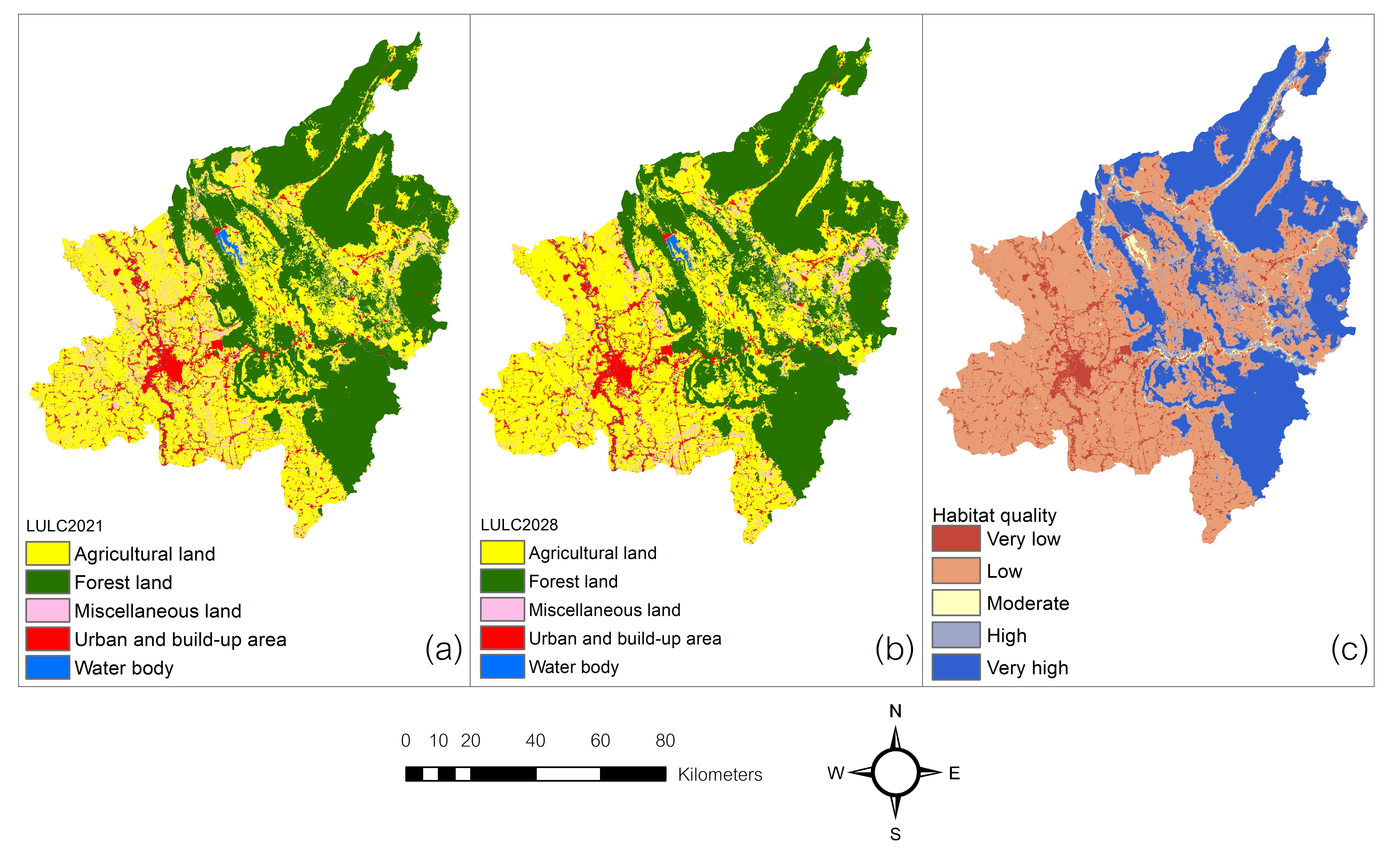
Main Results: The CA–Markov model demonstrated satisfactory predictive performance for land-use forecasting, achieving an Overall Accuracy of 0.87 and a Kappa coefficient of 0.79, indicating a high level of agreement between the simulated and actual land-use maps. The 2028 projection showed that urban and built-up areas were expected to increase from 6.08% to 6.42% of the provincial area, while agricultural land was projected to expand by 6.41%, and forest land showed a slight recovery of 0.57%. In contrast, miscellaneous land was projected to decline sharply, by as much as 40.51%, indicating that this land type functioned as the primary reservoir absorbing conversion into both agricultural and urban built-up areas as the province continued to develop. Assessment using the InVEST Habitat Quality model further showed that overall habitat quality declined from 0.544 in 2007 to 0.528 in 2028, while the corresponding habitat degradation index rose from 0.137 to 0.154 over the same period. Spatially, areas experiencing high habitat degradation expanded outward from the urban core toward peri-urban zones and the surrounding agricultural areas, particularly along the major road network and the transitional zones bordering forest edges. Notably, these areas of high degradation coincided closely with the same locations classified as having very-low habitat quality, underscoring a consistent spatial pattern linking urban and infrastructure expansion to ecological deterioration.
Conclusions: The coupled CA-Markov and InVEST Habitat Quality modeling framework effectively demonstrates the land-use dynamics of Phitsanulok Province, showing that these changes are driven primarily by transportation systems and continued urban expansion, both of which exert a direct and inverse effect on ecosystem quality. Although the province's extensive forest cover helps to moderate the overall provincial-level rate of decline in habitat quality, urban fringes, major roads, and the transition zones between urban areas and forest land remain at considerable long-term risk of habitat fragmentation. The knowledge generated through this study can serve as a foundation for supporting urban planning efforts, the delineation of ecological buffer zones, and the management of urban expansion, all of which are necessary to achieve a sustainable balance between continued economic development and the conservation of biodiversity in the province.
References
Arsanjani, J. J., Helbich, M., Kainz, W., & Boloorani, A. D. (2013). Integration of logistic regression, Markov chain and cellular automata models to simulate urban expansion. International Journal of Applied Earth Observation and Geoinformation, 21, 265–275. https://doi.org/10.1016/j.jag.2011.12.014
Arunyawat, S., & Shrestha, R. P. (2016). Assessing land use change and its impact on ecosystem services in northern Thailand. Sustainability, 8(8), 768. https://doi.org/10.3390/su8080768
Caro, T., Rowe, Z., Berger, J., Wholey, P., & Dobson, A. (2020). An inconvenient misconception: Climate change is not the principal driver of biodiversity loss. Conservation Letters, 15(3), e12868. https://doi.org/10.1111/conl.12868
Cohen, J. (1960). A coefficient of agreement for nominal scales. Educational and Psychological Measurement, 20(1), 37–46. https://doi.org/10.1177/001316446002000104
Congalton, R. G., & Green, K. (2009). Assessing the accuracy of remotely sensed data: Principles and practices (2nd ed.). CRC Press. https://doi.org/10.1201/9781420055139
Eastman, J. R. (2016). TerrSet: Geospatial monitoring and modeling system. Clark Labs, Clark University.
Fitawok, M., Derudder, B., Minale, A., Passel, S., Adgo, E., & Nyssen, J. (2020). Modeling the impact of urbanization on land-use change in Bahir Dar City, Ethiopia: An integrated cellular automata–Markov chain approach. Land, 9(4), 115. https://doi.org/10.3390/land9040115
Fitzpatrick-Lins, K. (1981). Comparison of sampling procedures and data analysis for a land-use and land-cover map. Photogrammetric Engineering and Remote Sensing, 47(3), 343-351.
Fleiss, J. L., Levin, B., & Paik, M. C. (2013). Statistical methods for rates and proportions (3rd ed.). John Wiley & Sons.
Foley, J. A., DeFries, R., Asner, G. P., Barford, C., Bonan, G., Carpenter, S. R., & Snyder, P. K. (2005). Global consequences of land use. Science, 309(5734), 570–574. https://doi.org/10.1126/science.1111772
Halmy, M. W. A., Gessler, P. E., Hicke, J. A., & Salem, B. B. (2015). Land use/land cover change detection and prediction in the north-western coastal desert of Egypt using Markov–CA. Applied Geography, 63, 101–112. https://doi.org/10.1016/j.apgeog.2015.06.015
Koko, A. F., Yue, W., Abubakar, G. A., Hamed, R., & Alabsi, A. A. (2020). Monitoring and predicting spatio-temporal land use/land cover changes in Zaria City, Nigeria, through an integrated cellular automata and Markov chain model (CA-Markov). Sustainability, 12(24), 10452. https://doi.org/10.3390/su122410452
Li, Z., Ma, Z., & Zhou, G. (2022). Impact of land use change on habitat quality and regional biodiversity capacity: Temporal and spatial evolution and prediction analysis. Frontiers in Environmental Science, 10, 1041573.https://doi.org/10.3389/fenvs.2022.1041573
Manna, H., Pramanik, M., Pal, R., Sarkar, S., Zhran, M., & Halder, B. (2025). Land use land cover change and habitat quality degradation in the tropical megacity of Bangkok: An integrated CA–Markov and InVEST modeling approach (1995–2045). Environmental and Sustainability Indicators, 28, 101036. https://doi.org/10.1016/j.indic.2025.101036
Office of Natural Resources and Environmental Policy and Planning. (2023). Guidelines for the preparation of environmental impact assessment reports for transportation projects. Ministry of Natural Resources and Environment. https://eia.onep.go.th (in Thai)
Sang, L., Zhang, C., Yang, J., Zhu, D., & Yun, W. (2011). Simulation of land use spatial pattern of towns and villages based on CA–Markov model. Mathematical and Computer Modelling, 54(3-4), 938-943. https://doi.org/10.1016/j.mcm.2010.11.019
Sharp, R., Tallis, H., Ricketts, T., Guerry, A., Wood, S., Chaplin-Kramer, R. & Wolny, S. (2020). InVEST user's guide: Integrated valuation of ecosystem services and tradeoffs. The Natural Capital Project, Stanford University. https://storage.googleapis.com/releases.naturalcapitalproject.org/invest-userguide/latest/en/habitat_quality.html
Singh, S. K., Mustak, S., Srivastava, P. K., Szabó, S., & Islam, T. (2015). Predicting spatial and decadal LULC changes through cellular automata Markov chain models using earth observation datasets and geo-spatial techniques. Environmental Earth Sciences, 73(8), 4673–4688. https://doi.org/10.1007/s40710-015-0062-x
Tang, Z., Ning, R., Wang, D., Tian, X., Bi, X., Ning, J., Zhou, Z., & Luo, F. (2024). Projections of land use/cover change and habitat quality in the model area of Yellow River delta by coupling land subsidence and sea level rise. Ecological Indicators, 158, 111394. https://doi.org/10.1016/j.ecolind.2023.111394
Trisurat, Y., Alkemade, R., & Verburg, P. H. (2010). Projecting land-use change and its consequences for biodiversity in Northern Thailand. Environmental Management, 45(3), 626-639. https://doi.org/10.1007/s00267-010-9438-x
Wang, G., Zhao, Q., & Jia, W. (2024). Spatio-temporal differentiation and driving factors of land use and habitat quality in Lu'an City, China. Land, 13(6), 789. https://doi.org/10.3390/land13060789
Wang, P., Li, X., Zhao, Y., & Zhang, K. (2025). InVEST model and landscape indices reveal habitat quality degradation from land use changes in South China. Ecology and Evolution, 15(2), e72719. https://doi.org/10.1002/ece3.72719
Wu, J., Li, X., Luo, Y., & Zhang, D. (2021). Spatiotemporal effects of urban sprawl on habitat quality in the Pearl River Delta from 1990 to 2018. Scientific Reports, 11, 13981. https://doi.org/10.1038/s41598-021-92916-3
Xie, B., & Zhang, M. (2023). Spatio-temporal evolution and driving forces of habitat quality in Guizhou Province. Scientific Reports, 13, 6908. https://doi.org/10.1038/s41598-023-33903-8
Yi, Y., Zhang, C., Zhu, J., Zhang, Y., Sun, H., & Kang, H. (2022). Spatio-temporal evolution, prediction and optimization of LUCC based on CA-Markov and InVEST models: A case study of Mentougou District, Beijing. International Journal of Environmental Research and Public Health, 19(4), 2432. https://doi.org/10.3390/ijerph19042432
Zhang, Y., Liu, Y., Zhang, X., & Wang, Z. (2021). Impacts of urban expansion on habitat quality in the Huaihe River Basin, China. Ecological Indicators, 125, 107496. https://doi.org/10.1016/j.ecolind.2021.107496
Zheng, X., & Li, Y. (2022). Urban expansion and habitat quality degradation: A coupled CA–Markov and InVEST modeling approach. Sustainability, 14(20), 13302. https://doi.org/10.3390/su142013302
Downloads
Published
How to Cite
Issue
Section
License
Copyright (c) 2026 Faculty of Science, Burapha University

This work is licensed under a Creative Commons Attribution-NonCommercial-NoDerivatives 4.0 International License.
Burapha Science Journal is licensed under a Creative Commons Attribution-NonCommercial-NoDerivatives 4.0 International (CC BY-NC-ND 4.0) licence, unless otherwise stated. Please read our Policies page for more information