
Usage of Camera System to Monitor the Rip Current Characteristics along Kata Noi Beach, Phuket Province
Keywords:
rip currents , CCTV, drone, RTK GNSS NetworkAbstract
Background and Objectives: Rip currents are a significant oceanographic hazard occurring along coastlines worldwide, posing serious risks to swimmers and beachgoers. These narrow, fast-moving, seaward-directed flows can lead to numerous drowning incidents and require frequent rescue operations. Typically, rip currents form at discontinuities in nearshore bathymetry, such as breaks in sandbars, and are often observed adjacent to hard coastal structures like jetties, groynes, and piers. Their occurrence can be temporally persistent, lasting from several hours to multiple days, and their velocities often exceed 0.5 m/s, occasionally reaching dangerous levels for even experienced swimmers. Given their hazardous nature, rip currents have become a subject of increasing scientific attention, particularly regarding their prediction, detection, and public awareness. However, despite their global prevalence, research into rip currents in Thailand remains limited. Existing mitigation strategies in the region predominantly focus on reactive measures, such as warning signage and lifeguard interventions, with little emphasis on proactive, science-based prevention and localized risk assessment. Phuket, located along Thailand’s Andaman Sea coastline, is among the country's most popular tourist destinations, drawing millions of domestic and international visitors annually. The island's western-facing beaches—including Kamala, Patong, Karon, Kata, and Kata Noi—are particularly vulnerable to rip currents due to their exposure to southwest monsoon swell, seasonal longshore sediment transport, and dynamic nearshore morphologies. Kata Noi Beach, situated on the southwestern coast of Phuket Province, has been identified as a high-risk area for rip current-related incidents. The beach experiences seasonal wave energy influxes, and its nearshore bathymetry is conducive to the formation of persistent and hazardous rip currents. Notably, multiple incidents, including a fatal drowning in 2021, underscore the need for targeted research and improved coastal safety management in this location. This study aims to characterize the formation, location, and dynamics of rip currents at Kata Noi Beach. The primary objectives are (1) to identify and spatially delineate rip current hotspots and (2) to determine the key hydrodynamic and geomorphologic factors influencing their development. To achieve these goals, a combination of in-situ field observations, UAV-based aerial surveys, and high-resolution bathymetric mapping was employed. The results of this study provide critical insights into the behavior and variability of rip currents at Kata Noi Beach. These findings are intended to inform the development of localized early warning systems and contribute to enhanced coastal risk management practices in Thailand. By integrating scientific observation with practical safety applications, this research supports efforts to reduce drowning incidents and improve public safety along Thai beaches.
Methodology: Fieldwork was conducted at Kata Noi Beach from 2022 to 2023 during the southwest monsoon (September 2022) and the northeast monsoon (January 2023). The research approach consisted of two sections. The first part, which involved coastal morphology and sediment analysis, was conducted through topographic surveys and sediment analyses. Topographic surveys were conducted using a Titan7 RTK GNSS system, and sediment samples were analyzed using the wet-sieve method to classify grain sizes and sediment types across tidal zones. The second part, Rip current monitoring, was implemented in conjunction with aerial surveys and fixed CCTV footage. DJI Mavic 3 Enterprise drone was used to capture aerial imagery and generate orthophotos and Digital Elevation Models (DEMs) via QGIS and WebODM. A fixed CCTV camera was installed at 7.805357°N, 98.299179°E to record continuous 24-hour video from September 2022 to February 2023. Video footages were processed using DaVinci Resolve to enhance imagery and identify rip current movement.
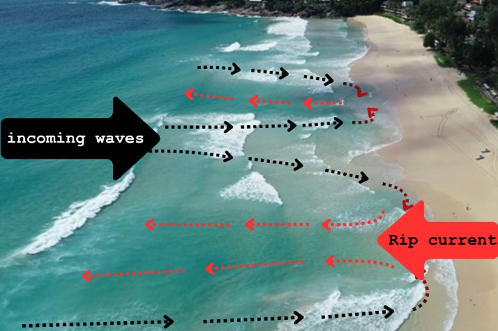
Main Results: Kata Noi Beach features a relatively straight, sandy shoreline shaped by seasonal monsoons: the southwest monsoon (June–September) and the northeast monsoon (November–February). Findings indicate that wave energy driven by these monsoons significantly influences coastal morphology. Finer sediments accumulate near the low-tide line, whereas coarser materials are more prevalent in the high-tide and intertidal zones. The beach slope varies with the seasons, ranging from 1.29° to 18.72° during the southwest monsoon, and from 0.72° to 7.61° during the northeast monsoon. Parallel subaqueous sandbars were identified offshore, separated by intermittent channels roughly 40 meters wide. Rip currents were consistently observed within these channels during the southwest monsoon only, repeatedly forming in the same or adjacent areas, indicating the presence of channelized or fixed rip currents. These currents were most visible during ebb tides, when lower water levels enhanced wave breaking, increasing the likelihood of rip current development. The results underscore the role of tidal cycles in influencing rip current behavior.
Conclusion: This study effectively identified and characterized the spatial and temporal behavior of rip currents at Kata Noi Beach through an integrated approach that combined field surveys, GIS data analysis, and continuous visual monitoring. The findings confirm that fixed rip currents occur during the southwest monsoon. The contribution factors to Rip current dynamics are composed of ocean wave characteristics, which are controlled by wind, beach morphology, and water elevation due to tidal variations. However, oceanographic data (water levels, currents, and ocean waves) are still necessary to provide complete information. Indeed, collecting oceanographic data during adverse weather conditions (monsoon) is challenging due to safety concerns and limitations of observational methods. Therefore, a new technique is required. The research highlights the importance of proactive coastal monitoring and real-time early warning systems development. The use of drones and CCTV monitoring proved to be effective and cost-efficient tools that can be applied in other high-risk coastal areas. These insights support coastal safety strategies, emergency preparedness, and sustainable beach tourism in Thailand while promoting the continued use of technology for real-time hazard surveillance.
References
Arozarena Llopis, I., Houser, C., Echeverria, A., & Brannstrom, C. (2015). The rip current hazard in Costa Rica. Natural Hazards, 77.
Austin, M., Scott, T., Brown, J., Brown, J., MacMahan, J., Masselink, G., & Russell, P. (2010). Temporal observations of rip current circulation on a macro-tidal beach. Continental Shelf Research, 30(9), 1149-1165.
Bang, I., Kim, K., Gu, J.-b., Shin, S.-m., Kim, J., & Kang, B. (2024). A Kinematic Approach for Rip Current Identification from ADCP Observation Data at Haeundae Beach, Korea. Ocean Science Journal, 59.
Brewster, B. C., Gould, R. E., & Brander, R. W. (2019). Estimations of rip current rescues and drowning in the United States. Nat. Hazards Earth Syst. Sci., 19(2), 389-397.
Brighton, B., Sherker, S., Brander, R., Thompson, M., & Bradstreet, A. (2013). Rip current related drowning deaths and rescues in Australia 2004–2011. Nat. Hazards Earth Syst. Sci., 13(4), 1069-1075.
Buscombe, D., Carini, R. J., Harrison, S., Chickadel, C. C., & Warrick, J. (2019). Optical wave gauging using deep neural networks. Coastal Engineering, 155.
Castelle, B., Scott, T., Brander, R. W., & McCarroll, R. J. (2016). Rip current types, circulation and hazard. Earth-Science Reviews, 163, 1-21.
Chang, S.-Y., Kim, J.-H., Lee, H.-S., & Kim, I. (2021). Mechanism of Rip Current Generation at Deoksan Beach, South Korea. Journal of Coastal Research, 295-299.
(CRCD), C. R. C. D. (2023). Final Report on the Study and assessment of coastal erosion vulnerability project: Case study of coastal areas in western Phuket province. Department of Marine and Coastal Resources. Bangkok.
de Silva, A., Mori, I., Dusek, G., Davis, J., & Pang, A. (2021). Automated Rip Current Detection with Region based Convolutional Neural Networks.
Diez-Fernández, P., Ruibal-Lista, B., Lobato-Alejano, F., & López-García, S. (2023). Rip current knowledge: do people really know its danger? do lifeguards know more than the general public? Heliyon, 9(7), e18104.
DMCR. (2022). Rip Currents. https://km.dmcr.go.th/c_274/d_19638
Eom, H., Yun, J., Jeong, C., Seo, J., & You, S. (2014, 11/02). Introduction to KMA Operational Forecasting System for Rip Current. Journal of Coastal Research, 72.
Haller, M., Honegger, D., & Catalán, P. (2014). Rip Current Observations via Marine Radar. Journal of Waterway Port Coastal and Ocean Engineering, 140, 115-124.
Hamsan, M. A. S., & Ramli, M. Z. (2021). Monsoonal influences on rip current hazards at recreational beaches along Pahang coastline, Malaysia. Ocean & Coastal Management, 209, 105689.
Hong, X., Zhang, Y., Wang, B., Shuihua, Z., Yu, S., & Zhang, J. (2021). Numerical study of rip currents interlaced with multichannel sandbars. Natural Hazards, 108.
Hu, P., Li, Z., Zhu, D., Zeng, C., Liu, R., Chen, Z., & Su, Q. (2022). Field observation and numerical analysis of rip currents at Ten-Mile Beach, Hailing Island, China. Estuarine, Coastal and Shelf Science, 276, 108014.
Jooyong, L., & Sungnam, H. (2022). Morphodynamics of Rip Current Systems at Haeundae Beach, Korea. Journal of Coastal Research, 39(1), 199-206.
Kim, D.-H. (2021, 2021/09/01/). Flash rip current driven suspended sediment flushing amplification in depth-integrated modeling framework. Advances in Water Resources, 155, 103997.
Kim, H. D., & Kim, K.-H. (2021). Analysis of Rip Current Characteristics Using Dye Tracking Method. Atmosphere, 12(6).
Kim, S., & Kim, D. (2024). Short-term buoyant microplastic transport patterns driven by wave evolution, breaking, and orbital motion in coast. Marine pollution bulletin, 201, 116248.
Liu, Y., & Wu, C. (2019). Lifeguarding Operational Camera Kiosk System (LOCKS) for flash rip warning: Development and application. Coastal Engineering, 152, 103537.
MacMahan, J. H., Thornton, E. B., & Reniers, A. J. H. M. (2006). Rip current review. Coastal Engineering, 53(2), 191-208.
McLean, R., Thom, B., Shen, J., & Oliver, T. (2023). 50 years of beach–foredune change on the southeastern coast of Australia: Bengello Beach, Moruya, NSW, 1972–2022. Geomorphology, 439, 108850.
Mori, I., de Silva, A., Dusek, G., Davis, J., & Pang, A. (2022). Flow-Based Rip Current Detection and Visualization. IEEE Access, PP, 1-1.
Mucerino, L., Carpi, L., Schiafno, C., Pranzini, E., Sessa, E., & Ferrari, M. (2021). Correction to: Rip current hazard assessment on a sandy beach in Liguria, NW Mediterranean. Natural Hazards, 105, 1-1.
Nitinrangkul, P., & Ritphring, S. (2023). Shoreline Detection with CoastSat Toolkit at Tourism Beaches of Phuket Island. The 28th National Convention on Civil Engineering, 28(0), WRE05-01-WRE05-09.
Rashid, A. H., Razzak, I., Tanveer, M., & Hobbs, M. (2023). Reducing rip current drowning: An improved residual based lightweight deep architecture for rip detection. ISA Transactions, 132,199-207.
Scott, T., Austin, M., Masselink, G., & Russell, P. (2016). Dynamics of rip currents associated with groynes — field measurements, modelling and implications for beach safety. Coastal Engineering, 107, 53-69.
Surisetty, A. K., Venkateswarlu, C., Madipally, R., Gireesh, B., Naidu, c. v., Nair, L. S., & Sharma, R. (2023). Practical use of smartphone cameras in rip current monitoring studies. Ocean & Coastal Management, 243, 106776.
Tang, W., Chen, Q., Zong, Y., Zhang, F., Wang, Y., & Jia, J. (2024). Risk assessment of rip current in China: based on data from 33 beaches. Geo-Marine Letters, 45.
Ventura, D., Napoleone, F., Cannucci, S., Alleaume, S., Valentini, E., Casoli, E., & Burrascano, S. (2022). Integrating low-altitude drone based-imagery and OBIA for mapping and manage semi natural grassland habitats. Journal of Environmental Management, 321.
Zhang, Y., Huang, W., Liu, X., Zhang, C., Xu, G., & Wang, B. (2021). Rip current hazard at coastal recreational beaches in China. Ocean & Coastal Management, 210, 105734.
Downloads
Published
How to Cite
Issue
Section
License
Copyright (c) 2025 Faculty of Science, Burapha University

This work is licensed under a Creative Commons Attribution-NonCommercial-NoDerivatives 4.0 International License.
Burapha Science Journal is licensed under a Creative Commons Attribution-NonCommercial-NoDerivatives 4.0 International (CC BY-NC-ND 4.0) licence, unless otherwise stated. Please read our Policies page for more information