
An Application of Machine Learning for Mangrove Heath Assessment with Unmanned Aerial Vehicle
Keywords:
mangrove health, UAV, Vegetation Index, machine learningAbstract
Background and Objectives: Mangrove forests are important tropical ecosystems that play significant ecological and economic roles. They function as carbon sinks, provide habitats for diverse species, reduce coastal erosion, and treat wastewater before discharge into the sea. Therefore, monitoring and assessing mangrove forest health is essential for biodiversity conservation and sustainable coastal management. However, traditional approaches for assessing mangrove health mainly rely on field surveys, which are time-consuming, resource-intensive, and unable to comprehensively cover large areas. The application of remote sensing technologies, such as satellite imagery and Unmanned Aerial Vehicle (UAV) imagery, has therefore become an important tool. Although satellite imagery can cover extensive areas, cloud cover and atmospheric disturbances pose major limitations to image quality, particularly in tropical humid regions. High-resolution UAV imagery thus represents an alternative for mangrove health assessment. Assessments based on UAV imagery commonly employ vegetation indices in combination with machine learning (ML) techniques; however, studies focusing on mangrove health assessment using UAV data remain limited. Accordingly, this study aims to select appropriate vegetation indices for classifying mangrove health from multispectral UAV imagery and to develop machine learning–based classification models to enable efficient and accurate monitoring of mangrove health changes.
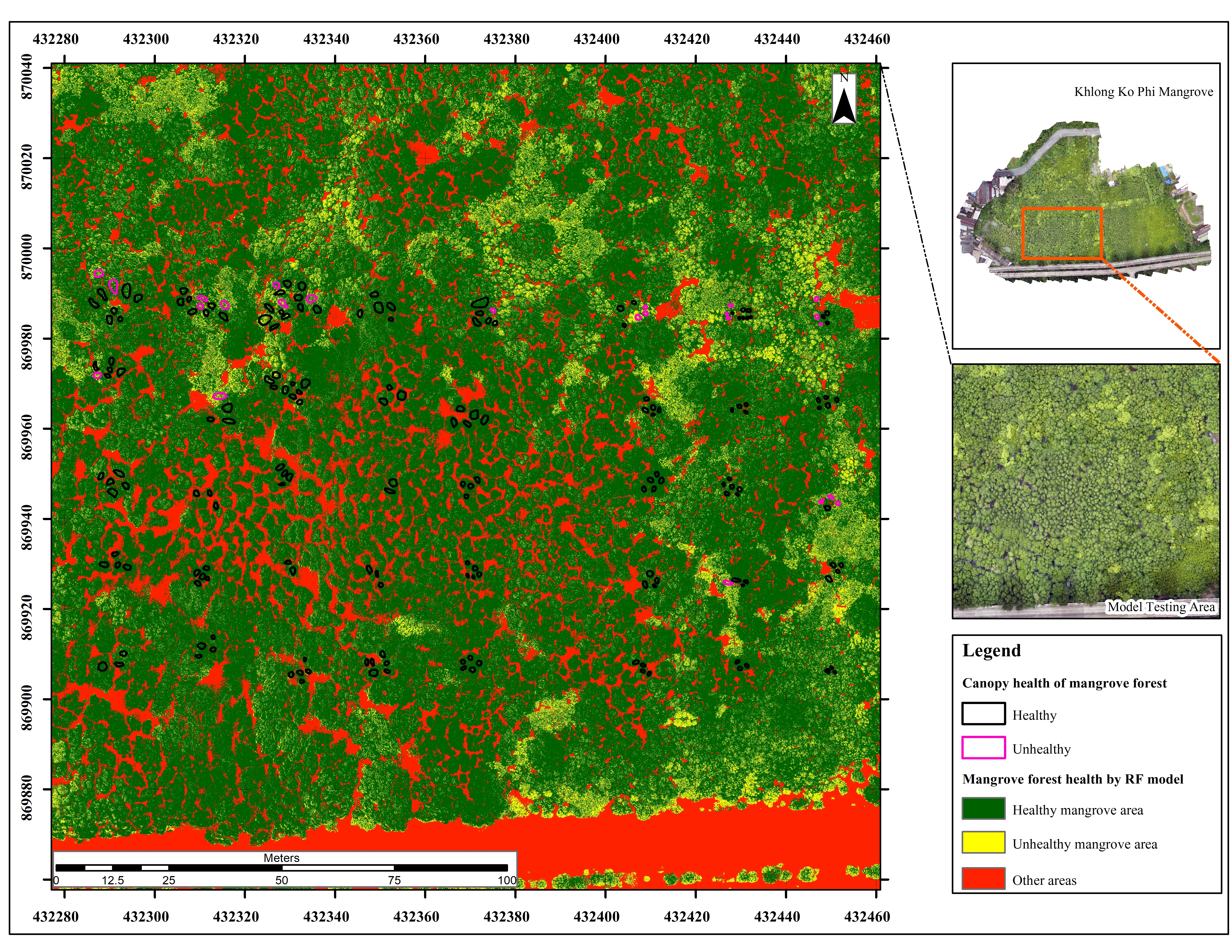
Methodology: This study was conducted in the mangrove forest of Khlong Koh Phi, Phuket Province. Two types of data were collected: field data obtained by measuring leaf spectral reflectance using a spectroradiometer, and multispectral UAV imagery acquired during the summer and rainy seasons. Sixteen vegetation indices were calculated, including NDVI (Normalized Difference Vegetation Index), GNDVI (Green Normalized Difference Vegetation Index), NDWI (Normalized Difference Water Index), SAVI (Soil Adjusted Vegetation Index), EVI (Enhanced Vegetation Index), NDRE (Normalized Difference Red Edge Index), NDI (Normalized Difference Index), TCARI (Transformed Chlorophyll Absorption Ratio Index), RECI (Red Edge Chlorophyll Index), CCCI (Canopy Chlorophyll Content Index), GCC (Green Chromatic Coordinate), VDVI (Visible Difference Vegetation Index), MTCI (MERIS Terrestrial Chlorophyll Index), ExG (Excess Green Index), PSRI (Plant Senescence Reflectance Index), and VARI (Visible Atmospherically Resistant Index). Mangrove canopy images were collected using UAV at predefined locations and classified into healthy and unhealthy categories based on visual interpretation of leaf color, canopy density, and structural abnormalities. The visual classification results were validated by comparison with plant health analysis obtained from the spectroradiometer. The health boundaries were then extended to other tree canopies to serve as reference data for ML model development. Averaged vegetation index values were calculated within the defined health boundaries, and indices capable of distinguishing between healthy and unhealthy canopies were selected using boxplot analysis as input variables for three ML models: Random Forest (RF), Support Vector Machine (SVM), and Extreme Gradient Boosting (XGBoost). The classification results were divided into three classes: healthy areas, unhealthy areas, and other areas (water, mud, and built-up areas). Each model was trained 50 times, with data split into training and testing sets at a ratio of 70:30 in each iteration. The model achieving the highest Overall Accuracy (OA) was selected as the most suitable model. All analytical processes were conducted using Python.
Main Results: The results indicated that 6 out of the 16 vegetation indices could distinguish between healthy and unhealthy mangrove canopies: GNDVI, NDWI, NDRE, CCCI, ExG, and MTCI. When these six indices were used as input variables for the three ML models (RF, SVM, and XGBoost), RF achieved the highest classification performance, with an Overall Accuracy of 77% and a Kappa coefficient of 0.62. The developed model was further tested on areas outside the training dataset. For the healthy class, Producer’s Accuracy was 99% and User’s Accuracy was 95%. For the unhealthy class, although Producer’s Accuracy was 61%, User’s Accuracy reached 88%, indicating the model’s potential for effective plant health analysis.
Conclusions: This study applied three machine learning algorithms RF, SVM, and XGBoost in combination with multispectral UAV imagery to assess mangrove forest health. The findings confirm that UAV imagery has high potential for plant health classification. Among the tested models, RF combined with six vegetation indices (GNDVI, NDWI, NDRE, CCCI, ExG, and MTCI) produced the best results. The developed model can be used to monitor mangrove health in both dry and rainy seasons and to support restoration, management, and long-term systematic monitoring of mangrove forest resources.
References
Abdollahnejad, A., & Panagiotidis, D. (2020). Tree species classification and health status assessment for a mixed broadleaf-conifer forest with UAS multispectral imaging. Remote Sensing, 12(22), 372.
Abdullah, W. M., & Yaakob, S. N. (2017). Modified excess green vegetation index for uneven illumination. International Journal of Current Research, 9, 48656–48661.
Alatorre, L. C., Sánchez-Carrillo, S., Miramontes-Beltrán, S., Medina, R. J., Torres-Olave, M. E., Bravo, L. C., Wiebe, L. C., Granados, A., Adams, D. K., Sánchez, E., & Uc, M. (2016). Temporal changes of NDVI for qualitative environmental assessment of mangroves: Shrimp farming impact on the health decline of the arid mangroves in the Gulf of California (1990–2010). Journal of Arid Environments, 125, 98–109.
Amatayakul, P., & Chomtha, T. (2017). Agricultural meteorology to know for Phuket. Thai Meteorological Department. (in Thai)
Aziz, G., Minallah, N., Saeed, A., Frnda, J., & Khan, W. (2023). Remote sensing based forest cover classification using machine learning. Scientific Reports, 14, 69.
Barnes, E. M., Clarke, T. R., Richards, S. E., Colaizzi, P. D., Haberland, J., Kostrzewski, M., Waller, P., Choi, C., Thompson, T., Lascano, R. J., Li, H., & Moran, M. S. (2000). Coincident detection of crop water stress, nitrogen status and canopy density using ground-based multispectral data. In Proceedings of the 5th International Conference on Precision Agriculture.
Bento, V. A., Gouveia, C. M., DaCamara, C. C., & Trigo, I. F. (2018). A climatological assessment of drought impact on vegetation health index. Agricultural and Forest Meteorology, 259, 286–295.
Budiarto, R., & Dewanto, B. G. (2025). Unmanned aerial vehicles for assessing biomass and carbon stocks in mangrove forests: A systematic review. Sustainable Futures, 10, 101425.
Chen, Y., Fang, S., Sun, M., Liu, Z., Pan, L., Mo, W., & Chen, C. (2022). Mangrove growth monitoring based on camera visible images: A case study on typical mangroves in Guangxi. Frontiers in Earth Science, 9, 771753.
Dash, J., & Curran, P. J. (2004). The MERIS terrestrial chlorophyll index. International Journal of Remote Sensing, 25(23), 5403–5413.
Dash, J., Curran, P. J., Tallis, M. J., Llewellyn, G. M., Taylor, G., & Snoeijf, P. (2010). Validating the MERIS terrestrial chlorophyll index (MTCI) with ground chlorophyll content data at MERIS spatial resolution. International Journal of Remote Sensing, 31(20), 5513–5532.
De Dominicis, M., Wolf, J., van Hespen, R., Zheng, P., & Hu, Z. (2023). Mangrove forests can be an effective coastal defence in the Pearl River Delta, China. Communications Earth & Environment, 4, 1–13.
Ecke, S., Stehr, F., Frey, J., Tiede, D., Dempewolf, J., Klemmt, H. J., Endres, E., & Seifert, T. (2024). Towards operational UAV-based forest health monitoring: Species identification and crown condition assessment by means of deep learning. Computers and Electronics in Agriculture, 219, 108785.
Fanshuri, B. Al, Prayogo, C., Soemarno, Prijono, S., Arfarita, N. (2023). The reliability of Unmanned Aerial Vehicles (UAVs) equipped with multispectral cameras for estimating chlorophyll content, plant height, canopy area, and fruit total number of Lemons (Citrus limon). Sains Tanah–Journal Soil Sci. Agroclimatol, 20, 221–230.
Ghorbanian, A., Ahmadi, S. A., Amani, M., Mohammadzadeh, A., & Jamali, S. (2022). Application of artificial neural networks for mangrove mapping using multi-temporal and multi-source remote sensing imagery. Water, 14(2), 244.
Gitelson, A.A., Kaufman, Y.J., Merzlyak, M.N., 1996. Use of a green channel in remote sensing of global vegetation from EOS- MODIS. Remote Sens. Environ., 58, 289–298.
Gitelson, A. A., Gritz, Y., & Merzlyak, M. N. (2003). Relationships between leaf chlorophyll content and spectral reflectance and algorithms for non-destructive chlorophyll assessment in higher plant leaves. Journal of Plant Physiology, 160(3), 271–282.
Gitelson, A. A., Kaufman, Y. J., Stark, R., & Rundquist, D. (2002). Novel algorithms for remote estimation of vegetation fraction. Remote Sensing of Environment, 80(1), 76–87.
Guerra-Hernández, J., Díaz-Varela, R. A., Álvarez-González, J. G., & Rodríguez-González, P. M. (2021). Assessing a novel modelling approach with high resolution UAV imagery for monitoring health status in priority riparian forests. Forest Ecosystems, 8(61),1-21.
Haboudane, D., Miller, J. R., Tremblay, N., Zarco-Tejada, P. J., & Dextraze, L. (2002). Integrated narrow-band vegetation indices for prediction of crop chlorophyll content for application to precision agriculture. Remote Sensing of Environment, 81(2–3), 416–426.
Huete, A.R., 1988. A soil-adjusted vegetation index (SAVI). Remote Sens. Environ., 25, 295–309.
Huete, A., Didan, K., Miura, T., Rodriguez, E. P., & Gao, X. (2002). Overview of the radiometric and biophysical performance of the MODIS vegetation indices. Remote Sensing of Environment, 83, 195–213.
Kloos, S., Yuan, Y., Castelli, M., & Menzel, A. (2021). Agricultural drought detection with MODIS-based vegetation health indices in southeast Germany. Remote Sensing, 13(19), 3907.
Kureel, N., Sarup, J., Matin, S., Goswami, S., & Kureel, K. (2021). Modelling vegetation health and stress using hyperspectral remote sensing data. Modeling Earth Systems and Environment, 8, 733–748.
Li, S., Zhu, Z., Deng, W., Zhu, Q., Xu, Z., Peng, B., Guo, F., Zhang, Y., & Yang, Z. (2024). Estimation of aboveground biomass of different vegetation types in mangrove forests based on UAV remote sensing. Sustainable Horizons, 11, 100100.
Malinee, R., Stratoulias, D., & Nuthammachot, N. (2021). Detection of oil palm disease in plantations in Krabi Province, Thailand with high spatial resolution satellite imagery. Agriculture, 11, 251.
McFeeters SK. (1996). The use of the Normalized Difference Water Index (NDWI) in the delineation of open water features. International Journal of Remote Sensing,17(7),1425-1432.
Meebunmak, Y., Khamthana, P., Mungkhamanee, S., Boonmee, L., Intana, J., Yatniyom, P., & Sirisabjanan, L. (2020). Field notes: Important instrument for qualitative researchers. Journal of Nursing and Education, 13(3), 1–13. (in Thai)
Prabakaran, C., Singh, C. P., & Panigrahy, S. (2014). Assessment of the health status of Indian mangrove ecosystems using multi-temporal remote sensing data. Tropical Ecology, 55(2), 245–253.
Pokovai, K., Mészáros, J., Balog, K., Koós, S., Árvai, M., Fodor, N. (2025). Optical leaf area assessment supports chlorophyll estimation from UAV images. Smart Agric. Technol., 11, 1–10.
Purwanto, A. D., Wikantika, K., Deliar, A., & Darmawan, S. (2023). Decision tree and random forest classification algorithms for mangrove forest mapping in Sembilang National Park, Indonesia. Remote Sensing, 15(1), 16.
Reed, B.C., Brown, J.F., VanderZee, D., Loveland, T.R., Merchant, J.W., Ohlen, D.O., 1994. Measuring phenological variability from satellite imagery. J. Veg. Sci., 5, 703–714.
Ren, S., Chen, X., & An, S. (2017). Assessing plant senescence reflectance index-retrieved vegetation phenology and its spatiotemporal response to climate change in the Inner Mongolian grassland. International Journal of Biometeorology, 61(4), 601–612.
Richardson, A. D., Jenkins, J. P., Braswell, B. H., Hollinger, D. Y., Ollinger, S. V., & Smith, M. L. (2007). Use of digital webcam images to track spring green-up in a deciduous broadleaf forest. Oecologia, 152(2), 323–334.
Simarmata, N., Wikantika, K., Darmawan, S., Harto, A. B., & Santo, A. A. (2022). Evaluation of multispectral image for mangrove health assessment using Sentinel-2A and field spectrometer data. In 2022 IEEE International Conference on Aerospace Electronics and Remote Sensing Technology (ICARES) (pp. 1–7).
Tran, T. V., Reef, R., & Zhu, X. (2022). A review of spectral indices for mangrove remote sensing. Remote Sensing, 14(19), 4868.
Wang, L., Silván-Cárdenas, J. L., & Sousa, W. P. (2008). Neural network classification of mangrove species from multi-seasonal Ikonos imagery. Photogrammetric Engineering & Remote Sensing, 74(8), 921–926.
Wang, M., Zhang, T., Xie, Y., Zhang, Z., & Wu, X. (2025). Mapping accumulated carbon storage of global mangroves from 2000 to 2020 at a 1 km resolution. Scientific Data, 12, 1–17.
Wang, X., Wang, M., Wang, S., & Wu, Y. (2015). Extraction of vegetation information from visible unmanned aerial vehicle images. Transactions of the Chinese Society of Agricultural Engineering, 31, 152–159.
Woebbecke, D. M., Meyer, G. E., Von Bargen, K., & Mortensen, D. A. (1995). Color indices for weed identification under various soil, residue, and lighting conditions. Transactions of the ASAE, 38(1), 259–269.
Yin, D., Cai, Y., Li, Y., Yuan, W., & Zhao, Z. (2024). Assessment of the health status of old trees of Platycladus orientalis L. using UAV multispectral imagery. Drones, 8, 91.
Zhang, C., Kovacs, J. M., Liu, Y., Flores-Verdugo, F., & Flores-de-Santiago, F. (2014). Separating mangrove species and conditions using laboratory hyperspectral data: A case study of a degraded mangrove forest of the Mexican Pacific. Remote Sensing, 6, 11673–11688.
Downloads
Published
How to Cite
Issue
Section
License
Copyright (c) 2026 Faculty of Science, Burapha University

This work is licensed under a Creative Commons Attribution-NonCommercial-NoDerivatives 4.0 International License.
Burapha Science Journal is licensed under a Creative Commons Attribution-NonCommercial-NoDerivatives 4.0 International (CC BY-NC-ND 4.0) licence, unless otherwise stated. Please read our Policies page for more information

