
การประยุกต์ใช้การเรียนรู้ของเครื่องสำหรับการประเมินสุขภาพ ของป่าชายเลนด้วยอากาศยานไร้คนขับ
คำสำคัญ:
ป่าชายเลน, ภาพถ่ายทางอากาศ, ดัชนีพืชพรรณ, การเรียนรู้ของเครื่องบทคัดย่อ
วัตถุประสงค์และที่มา: ป่าชายเลนเป็นระบบนิเวศสำคัญในเขตร้อนที่มีบทบาททั้งด้านนิเวศวิทยาและเศรษฐกิจ ทำหน้าที่เป็นแหล่งกักเก็บคาร์บอน เป็นถิ่นอาศัยของสิ่งมีชีวิตหลากชนิด ช่วยลดการกัดเซาะชายฝั่ง และบำบัดน้ำเสียก่อนระบายลงสู่ทะเล ดังนั้น การติดตามและประเมินสุขภาพของป่าชายเลนจึงมีความสำคัญต่อการอนุรักษ์ความหลากหลายทางชีวภาพและการบริหารจัดการพื้นที่ชายฝั่งอย่างยั่งยืน อย่างไรก็ตาม วิธีการประเมินสุขภาพป่าชายเลนแบบดั้งเดิมส่วนใหญ่อาศัยการสำรวจภาคสนาม ซึ่งใช้เวลาและทรัพยากรสูง อีกทั้งยังไม่สามารถครอบคลุมพื้นที่ขนาดใหญ่ การประยุกต์เทคโนโลยีสำรวจระยะไกล (Remote Sensing) เช่น ภาพถ่ายดาวเทียม ภาพถ่ายจากอากาศยานไร้คนขับ (Unmanned Aerial Vehicle: UAV) จึงเป็นเครื่องมือที่สำคัญ แม้ภาพถ่ายดาวเทียมสามารถถ่ายภาพเป็นบริเวณกว้าง แต่เมฆและสิ่งรบกวนในชั้นบรรยากาศเป็นอุปสรรคสำคัญต่อคุณภาพของภาพถ่ายดาวเทียม โดยเฉพาะในเขตร้อนชื้น ดังนั้นภาพถ่ายจาก UAV ที่มีความละเอียดสูงจึงเป็นทางเลือกในการประเมินสุขภาพของป่าชายเลนได้ ทั้งนี้การประเมินสุขภาพของป่าชายเลนจากภาพถ่าย UAV มักอาศัยดัชนีพืชพรรณ (Vegetation Indices) ควบคู่กับเทคนิคการเรียนรู้ของเครื่อง (Machine Learning: ML) แต่การศึกษาเกี่ยวกับการประเมินสุขภาพป่าชายเลนด้วยข้อมูล UAV ยังมีอยู่จำกัด ดังนั้นงานวิจัยนี้จึงมีวัตถุประสงค์เพื่อคัดเลือกดัชนีพืชพรรณที่เหมาะสมสำหรับการจำแนกสุขภาพของป่าชายเลนจากภาพถ่าย UAV แบบหลายช่วงคลื่น (Multispectral) และพัฒนาแบบจำลองการจำแนกสุขภาพของป่าชายเลนโดยใช้อัลกอริทึมการเรียนรู้ของเครื่อง เพื่อให้สามารถติดตามการเปลี่ยนแปลงสุขภาพป่าชายเลนได้อย่างมีประสิทธิภาพและแม่นยำ
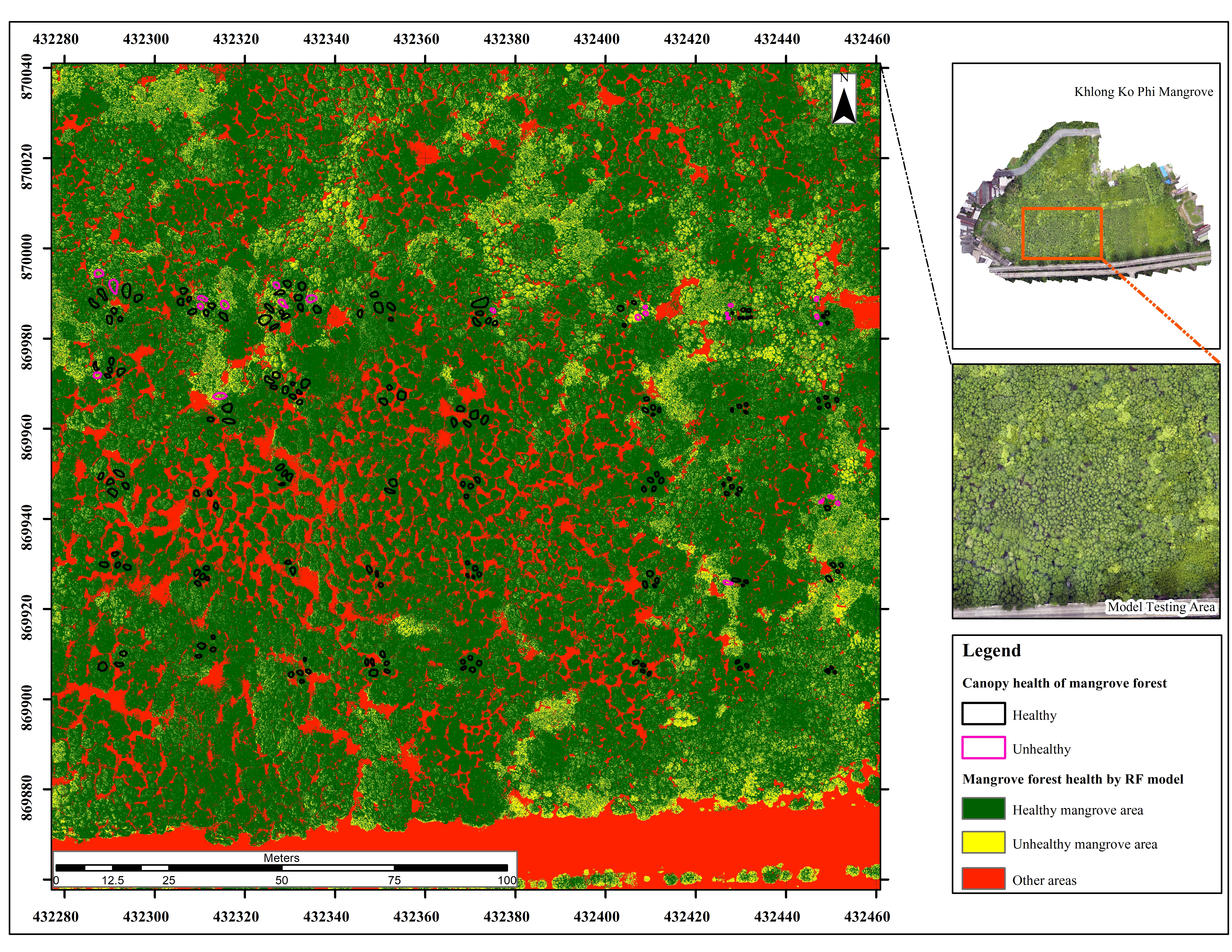
วิธีการดำเนินงานวิจัย: การศึกษานี้ดำเนินการในพื้นที่ป่าชายเลนคลองเกาะผี จังหวัดภูเก็ต โดยเก็บรวบรวมข้อมูล 2 ส่วน ได้แก่ข้อมูลภาคสนาม ด้วยการวัดค่าการสะท้อนเชิงสเปกตรัมของใบไม้โดยใช้เครื่อง Spectroradiometer และข้อมูลภาพถ่ายทางอากาศจาก UAV แบบ Multispectral จากฤดูร้อนและฤดูฝน เพื่อนำมาคำนวณดัชนีพืชพรรณจำนวน 16 ดัชนี ได้แก่ NDVI (Normalized Difference Vegetation Index), GNDVI (Green Normalized Difference Vegetation Index), NDWI (Normalized Difference Water Index), SAVI (Soil Adjusted Vegetation Index), EVI (Enhanced Vegetation Index), NDRE (Normalized Difference Red Edge Index), NDI (Normalized Difference Index), TCARI (Transformed Chlorophyll Absorption Ratio Index), RECI (Red Edge Chlorophyll Index), CCCI (Canopy Chlorophyll Content Index), GCC (Green Chromatic Coordinate), VDVI (Visible Difference Vegetation Index), MTCI (MERIS Terrestrial Chlorophyll Index), ExG (Excess Green Index), PSRI (Plant Senescence Reflectance Index) และ VARI (Visible Atmospherically Resistant Index) ภาพถ่ายเรือนยอดป่าชายเลนถูกจัดเก็บด้วย UAV ตามตำแหน่งที่กำหนดและนำมาจำแนกสภาพสุขภาพออกเป็นกลุ่มสุขภาพดีและสุขภาพไม่ดี โดยใช้การประเมินด้วยสายตาตามลักษณะสีใบ ความหนาแน่น และความผิดปกติของโครงสร้างเรือนยอด ผลการจำแนกด้วยสายตาถูกตรวจสอบความถูกต้องโดยเปรียบเทียบกับผลการวิเคราะห์สุขภาพพืชจากเครื่อง Spectroradiometer หลังจากนั้นได้ขยายการกำหนดขอบเขตสุขภาพไปยังเรือนยอดของต้นพืชอื่น ๆ เพื่อใช้เป็นข้อมูลอ้างอิงในการพัฒนาแบบจำลอง ML ค่าเฉลี่ยของดัชนีพืชพรรณถูกคำนวณภายในขอบเขตสุขภาพดังกล่าว และคัดเลือกเฉพาะดัชนีที่สามารถแยกความแตกต่างระหว่างเรือนยอดที่มีสุขภาพดีและสุขภาพไม่ดีด้วยวิธีแผนภาพกล่อง (Boxplot) เพื่อใช้เป็นตัวแปรต้นในการพัฒนาแบบจำลอง ML จำนวน 3 วิธี ได้แก่ อัลกอริทึมป่าแบบสุ่ม (Random Forest: RF) เครื่องเวกเตอร์สนับสนุน (Support Vector Machine: SVM) และการเพิ่มประสิทธิภาพเชิงลาดแบบขั้นสุด (Extreme Gradient Boosting: XGBoost) ผลการจำแนกถูกแบ่งออกเป็น 3 กลุ่ม ได้แก่ พื้นที่ที่มีสุขภาพดี พื้นที่ที่มีสุขภาพไม่ดี และพื้นที่อื่น ๆ (น้ำ โคลน และสิ่งปลูกสร้าง) แบบจำลองทั้งสามถูกฝึกซ้ำจำนวน 50 รอบ โดยในแต่ละรอบแบ่งข้อมูลสำหรับการฝึกและการทดสอบในอัตราส่วน 70:30 และเลือกแบบจำลองที่ให้ค่าความแม่นยำโดยรวม (Overall Accuracy) สูงที่สุดจะเป็นแบบจำลองที่เหมาะสมที่สุด ทั้งนี้กระบวนการวิเคราะห์ทั้งหมดดำเนินการด้วยภาษา Python
ผลการวิจัย: ผลการศึกษาพบว่ามีดัชนีพืชพรรณทั้งหมด 6 ดัชนีจากทั้งหมด 16 ดัชนี ที่สามารถแยกความแตกต่างของกลุ่มสุขภาพดีและไม่ดีได้ คือ GNDVI, NDWI, NDRE, CCCI, ExG และ MTCI ทั้งนี้เมื่อนำดัชนีทั้ง 6 ชนิดเป็นตัวแปรนำเข้าสู่แบบจำลอง ML ทั้ง 3 ชนิด (RF, SVM และ XGBoost) พบว่า RF ให้ผลการจำแนกแม่นยำสูงที่สุด ด้วยค่า Overall Accuracy เท่ากับ 77% และค่า Kappa = 0.62 แบบจำลองที่พัฒนาขึ้นยังถูกนำไปทดสอบกับพื้นที่นอกชุดข้อมูลฝึก พบว่ากลุ่มสุขภาพดีให้ค่า Producer’s Accuracy = 99% และ User’s Accuracy = 95% กลุ่มสุขภาพไม่ดีแม้มี Producer’s Accuracy = 61% แต่มี User’s Accuracy สูงถึง 88% แสดงถึงศักยภาพในการนำไปใช้วิเคราะห์สุขภาพพืชได้อย่างมีประสิทธิภาพ
สรุปผลการวิจัย: งานวิจัยนี้ประยุกต์อัลกอริทึมการเรียนรู้ของเครื่อง 3 ชนิด ได้แก่ RF, SVM และ XGBoost ร่วมกับข้อมูลภาพถ่าย UAV แบบ Multispectral เพื่อประเมินสุขภาพของป่าชายเลน ผลการศึกษายืนยันว่า ภาพถ่าย UAV มีศักยภาพสูงในการจำแนกสุขภาพพืช โดยแบบจำลอง RF ร่วมกับดัชนีพืชพรรณ 6 ดัชนี ได้แก่ GNDVI, NDWI, NDRE, CCCI, ExG และ MTCI ให้ผลลัพธ์ดีที่สุด แบบจำลองที่พัฒนาขึ้นสามารถใช้ในการติดตามสุขภาพของป่าชายเลนทั้งในฤดูร้อนและฤดูฝน รวมถึงสนับสนุนการฟื้นฟู บริหารจัดการ และติดตามการเปลี่ยนแปลงทรัพยากรป่าชายเลนได้อย่างเป็นระบบในระยะยาว
เอกสารอ้างอิง
Abdollahnejad, A., & Panagiotidis, D. (2020). Tree species classification and health status assessment for a mixed broadleaf-conifer forest with UAS multispectral imaging. Remote Sensing, 12(22), 372.
Abdullah, W. M., & Yaakob, S. N. (2017). Modified excess green vegetation index for uneven illumination. International Journal of Current Research, 9, 48656–48661.
Alatorre, L. C., Sánchez-Carrillo, S., Miramontes-Beltrán, S., Medina, R. J., Torres-Olave, M. E., Bravo, L. C., Wiebe, L. C., Granados, A., Adams, D. K., Sánchez, E., & Uc, M. (2016). Temporal changes of NDVI for qualitative environmental assessment of mangroves: Shrimp farming impact on the health decline of the arid mangroves in the Gulf of California (1990–2010). Journal of Arid Environments, 125, 98–109.
Amatayakul, P., & Chomtha, T. (2017). Agricultural meteorology to know for Phuket. Thai Meteorological Department. (in Thai)
Aziz, G., Minallah, N., Saeed, A., Frnda, J., & Khan, W. (2023). Remote sensing based forest cover classification using machine learning. Scientific Reports, 14, 69.
Barnes, E. M., Clarke, T. R., Richards, S. E., Colaizzi, P. D., Haberland, J., Kostrzewski, M., Waller, P., Choi, C., Thompson, T., Lascano, R. J., Li, H., & Moran, M. S. (2000). Coincident detection of crop water stress, nitrogen status and canopy density using ground-based multispectral data. In Proceedings of the 5th International Conference on Precision Agriculture.
Bento, V. A., Gouveia, C. M., DaCamara, C. C., & Trigo, I. F. (2018). A climatological assessment of drought impact on vegetation health index. Agricultural and Forest Meteorology, 259, 286–295.
Budiarto, R., & Dewanto, B. G. (2025). Unmanned aerial vehicles for assessing biomass and carbon stocks in mangrove forests: A systematic review. Sustainable Futures, 10, 101425.
Chen, Y., Fang, S., Sun, M., Liu, Z., Pan, L., Mo, W., & Chen, C. (2022). Mangrove growth monitoring based on camera visible images: A case study on typical mangroves in Guangxi. Frontiers in Earth Science, 9, 771753.
Dash, J., & Curran, P. J. (2004). The MERIS terrestrial chlorophyll index. International Journal of Remote Sensing, 25(23), 5403–5413.
Dash, J., Curran, P. J., Tallis, M. J., Llewellyn, G. M., Taylor, G., & Snoeijf, P. (2010). Validating the MERIS terrestrial chlorophyll index (MTCI) with ground chlorophyll content data at MERIS spatial resolution. International Journal of Remote Sensing, 31(20), 5513–5532.
De Dominicis, M., Wolf, J., van Hespen, R., Zheng, P., & Hu, Z. (2023). Mangrove forests can be an effective coastal defence in the Pearl River Delta, China. Communications Earth & Environment, 4, 1–13.
Ecke, S., Stehr, F., Frey, J., Tiede, D., Dempewolf, J., Klemmt, H. J., Endres, E., & Seifert, T. (2024). Towards operational UAV-based forest health monitoring: Species identification and crown condition assessment by means of deep learning. Computers and Electronics in Agriculture, 219, 108785.
Fanshuri, B. Al, Prayogo, C., Soemarno, Prijono, S., Arfarita, N. (2023). The reliability of Unmanned Aerial Vehicles (UAVs) equipped with multispectral cameras for estimating chlorophyll content, plant height, canopy area, and fruit total number of Lemons (Citrus limon). Sains Tanah–Journal Soil Sci. Agroclimatol, 20, 221–230.
Ghorbanian, A., Ahmadi, S. A., Amani, M., Mohammadzadeh, A., & Jamali, S. (2022). Application of artificial neural networks for mangrove mapping using multi-temporal and multi-source remote sensing imagery. Water, 14(2), 244.
Gitelson, A.A., Kaufman, Y.J., Merzlyak, M.N., 1996. Use of a green channel in remote sensing of global vegetation from EOS- MODIS. Remote Sens. Environ., 58, 289–298.
Gitelson, A. A., Gritz, Y., & Merzlyak, M. N. (2003). Relationships between leaf chlorophyll content and spectral reflectance and algorithms for non-destructive chlorophyll assessment in higher plant leaves. Journal of Plant Physiology, 160(3), 271–282.
Gitelson, A. A., Kaufman, Y. J., Stark, R., & Rundquist, D. (2002). Novel algorithms for remote estimation of vegetation fraction. Remote Sensing of Environment, 80(1), 76–87.
Guerra-Hernández, J., Díaz-Varela, R. A., Álvarez-González, J. G., & Rodríguez-González, P. M. (2021). Assessing a novel modelling approach with high resolution UAV imagery for monitoring health status in priority riparian forests. Forest Ecosystems, 8(61),1-21.
Haboudane, D., Miller, J. R., Tremblay, N., Zarco-Tejada, P. J., & Dextraze, L. (2002). Integrated narrow-band vegetation indices for prediction of crop chlorophyll content for application to precision agriculture. Remote Sensing of Environment, 81(2–3), 416–426.
Huete, A.R., 1988. A soil-adjusted vegetation index (SAVI). Remote Sens. Environ., 25, 295–309.
Huete, A., Didan, K., Miura, T., Rodriguez, E. P., & Gao, X. (2002). Overview of the radiometric and biophysical performance of the MODIS vegetation indices. Remote Sensing of Environment, 83, 195–213.
Kloos, S., Yuan, Y., Castelli, M., & Menzel, A. (2021). Agricultural drought detection with MODIS-based vegetation health indices in southeast Germany. Remote Sensing, 13(19), 3907.
Kureel, N., Sarup, J., Matin, S., Goswami, S., & Kureel, K. (2021). Modelling vegetation health and stress using hyperspectral remote sensing data. Modeling Earth Systems and Environment, 8, 733–748.
Li, S., Zhu, Z., Deng, W., Zhu, Q., Xu, Z., Peng, B., Guo, F., Zhang, Y., & Yang, Z. (2024). Estimation of aboveground biomass of different vegetation types in mangrove forests based on UAV remote sensing. Sustainable Horizons, 11, 100100.
Malinee, R., Stratoulias, D., & Nuthammachot, N. (2021). Detection of oil palm disease in plantations in Krabi Province, Thailand with high spatial resolution satellite imagery. Agriculture, 11, 251.
McFeeters SK. (1996). The use of the Normalized Difference Water Index (NDWI) in the delineation of open water features. International Journal of Remote Sensing,17(7),1425-1432.
Meebunmak, Y., Khamthana, P., Mungkhamanee, S., Boonmee, L., Intana, J., Yatniyom, P., & Sirisabjanan, L. (2020). Field notes: Important instrument for qualitative researchers. Journal of Nursing and Education, 13(3), 1–13. (in Thai)
Prabakaran, C., Singh, C. P., & Panigrahy, S. (2014). Assessment of the health status of Indian mangrove ecosystems using multi-temporal remote sensing data. Tropical Ecology, 55(2), 245–253.
Pokovai, K., Mészáros, J., Balog, K., Koós, S., Árvai, M., Fodor, N. (2025). Optical leaf area assessment supports chlorophyll estimation from UAV images. Smart Agric. Technol., 11, 1–10.
Purwanto, A. D., Wikantika, K., Deliar, A., & Darmawan, S. (2023). Decision tree and random forest classification algorithms for mangrove forest mapping in Sembilang National Park, Indonesia. Remote Sensing, 15(1), 16.
Reed, B.C., Brown, J.F., VanderZee, D., Loveland, T.R., Merchant, J.W., Ohlen, D.O., 1994. Measuring phenological variability from satellite imagery. J. Veg. Sci., 5, 703–714.
Ren, S., Chen, X., & An, S. (2017). Assessing plant senescence reflectance index-retrieved vegetation phenology and its spatiotemporal response to climate change in the Inner Mongolian grassland. International Journal of Biometeorology, 61(4), 601–612.
Richardson, A. D., Jenkins, J. P., Braswell, B. H., Hollinger, D. Y., Ollinger, S. V., & Smith, M. L. (2007). Use of digital webcam images to track spring green-up in a deciduous broadleaf forest. Oecologia, 152(2), 323–334.
Simarmata, N., Wikantika, K., Darmawan, S., Harto, A. B., & Santo, A. A. (2022). Evaluation of multispectral image for mangrove health assessment using Sentinel-2A and field spectrometer data. In 2022 IEEE International Conference on Aerospace Electronics and Remote Sensing Technology (ICARES) (pp. 1–7).
Tran, T. V., Reef, R., & Zhu, X. (2022). A review of spectral indices for mangrove remote sensing. Remote Sensing, 14(19), 4868.
Wang, L., Silván-Cárdenas, J. L., & Sousa, W. P. (2008). Neural network classification of mangrove species from multi-seasonal Ikonos imagery. Photogrammetric Engineering & Remote Sensing, 74(8), 921–926.
Wang, M., Zhang, T., Xie, Y., Zhang, Z., & Wu, X. (2025). Mapping accumulated carbon storage of global mangroves from 2000 to 2020 at a 1 km resolution. Scientific Data, 12, 1–17.
Wang, X., Wang, M., Wang, S., & Wu, Y. (2015). Extraction of vegetation information from visible unmanned aerial vehicle images. Transactions of the Chinese Society of Agricultural Engineering, 31, 152–159.
Woebbecke, D. M., Meyer, G. E., Von Bargen, K., & Mortensen, D. A. (1995). Color indices for weed identification under various soil, residue, and lighting conditions. Transactions of the ASAE, 38(1), 259–269.
Yin, D., Cai, Y., Li, Y., Yuan, W., & Zhao, Z. (2024). Assessment of the health status of old trees of Platycladus orientalis L. using UAV multispectral imagery. Drones, 8, 91.
Zhang, C., Kovacs, J. M., Liu, Y., Flores-Verdugo, F., & Flores-de-Santiago, F. (2014). Separating mangrove species and conditions using laboratory hyperspectral data: A case study of a degraded mangrove forest of the Mexican Pacific. Remote Sensing, 6, 11673–11688.
ดาวน์โหลด
เผยแพร่แล้ว
รูปแบบการอ้างอิง
ฉบับ
ประเภทบทความ
สัญญาอนุญาต
ลิขสิทธิ์ (c) 2026 คณะวิทยาศาสตร์ มหาวิทยาลัยบูรพา

อนุญาตภายใต้เงื่อนไข Creative Commons Attribution-NonCommercial-NoDerivatives 4.0 International License.
Burapha Science Journal is licensed under a Creative Commons Attribution-NonCommercial-NoDerivatives 4.0 International (CC BY-NC-ND 4.0) licence, unless otherwise stated. Please read our Policies page for more information

